The Council has published three options to simplify the Cumberland Basin road system which was constructed in an age that championed motorway-style urban road systems. The elevated roads and the swing bridge currently require extensive maintenance. The Society supports the ambition to release highway land to develop a new city quarter with space for new homes, with high quality green open space and improved and safer walking and cycling routes. The elevated roads harm the views of the Clifton Suspension Bridge, the Avon Gorge, Ashton Court and Bristol Harbour, a point taken up by the national press as this item in the Guardian illustrates.
The Council commissioned a report on the options to replace the road system from the Arup Group, international consulting engineers. The Society is critical of the current consultation. The public are asked to respond on information that the Council has chosen to publish whilst it has kept the Arup Report secret. The plans include only a low level of detail limited to transport routes. We cannot understand critical matters, for example the effect of each of the proposals on nearby communities. The consultation is a wasted opportunity. All the three options would have as great an impact on the area as the 1960s road system had when it was constructed.
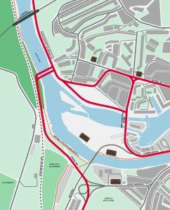
The Society’s concerns about the drawbacks and unanswered questions that relate to the three options are set out in the linked response (below). The Society would be surprised if the unpublished Arup report did not consider less ambitious options which have been discussed in the past. To repair the bridge and demolish several of the slip roads would cost less, would simplify and reduce the land occupied by roads and have a lower impact on the landscape to the west or the residential areas and release land for development. A more modest option would have a better chance of delivery. The image shows the Western Option with a new road on the Avon River’s west bank and a new bridge similar to the Bedminster Bridge gyratory.
John Frenkel
Western Harbour consultation flyer.
The Arup report (Western Harbour Feasibility Study: Final Transport Feasibility Report) shows the full list of 9 road options in an appendix.
The Mayor seems to want a Grand Plan with the hope that developers will fund it. However the most obvious option is to dispense with all of the complex road network at the end of Spike Island linking the road system to Cumberland Road. Given the amount of traffic that goes that way, even at the times of bridge swings, it’s all redundant. It might mean the loss of the Lockside cafe, which would be a shame but otherwise that seems the cheapest and least intrusive option all round.
The council presents several extravagant and destructive options with misleading graphics showing the new proposals in mere diagram form as opposed to the existing system which is shown in all its sprawling road-engineered excess.
As the Civic Society suggests, and as has evidently been proposed before, there are much simpler, cheaper and less destructive options which have either been overlooked or deliberately withheld in an attempt to convince the public that only more gratuitous road engineering can overcome the problems created by gratuitous road engineering in the first place.
The lack of any attempt at showing the multiple and substantial visual impacts of the various proposals is at best disingenuous and at worst deliberately misleading.
The last twenty years of understanding the damage of road-engineering-led town planning seems to have been completely forgotten.