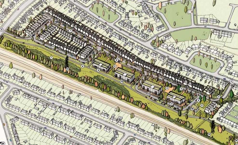
The Council proposes to build 188 new homes on land on south side of Bonnington Walk Lockleaze. The development will be ‘tenure blind’, a mix of private sale and affordable units (shared ownership and social rent) on, approximately, a 50/50 basis. This site has not been developed previously. The image shows the site surrounded on three sides by housing estates. The project is a mix of semi-detached houses, small terraces and small apartment blocks which will fit in with their surroundings.
The Society supports the principle of the development which is an appropriate use of under-used land. We support the proposed estate layout and the design and mix of new homes. The proposal accommodates the Concorde Way cycle route, the Site of Nature Conservation Interest, and the site trees and Lockleaze Community Orchard.
John Frenkel
I am most disappointed to see your comments on the Civic Society website that you are supporting the council’s proposed development of housing on Bonnington Walk Open Space. Almost all of what is written on your website is directly taken from the council’s press release and suggests a lack of knowledge of the site.
It is particularly galling that you have accepted the council’s classification of the area as “under-used land”. The implication that such land has little value is rejected by local residents who value the area as a habitat for numerous birds (including owls), bats, pollinators and small mammals, as well as such areas positive impact on mental and physical well-being. The loss of such a habitat will have a negative impact on wildlife and local people. As noted by Bristol Tree Forum, to remove about 200 trees is also inconsistent with the council’s policy on doubling the tree canopy or reducing carbon emissions. It would be better suited as a location for tree planting, rather than destruction. Although some of the site has been left to nature for 40 years (and such areas are considered to often have better biodiversity) it is classed as a brownfield site because it was allotments in the past. Despite your repetition of the council’s line, there is no guarantee that the SNCI, cycle path and community orchard will be protected, nor that the statements made about the proportion of social housing or “environmental improvements” to increase biodiversity will be honoured.
I would like to invite you to visit the site and see the layout and how it is a tree-filled oasis used and valued by many local residents.
I look forward to hearing from you. I would suggest that you look at the Facebook page (details below) to see pictures of the site and our concerns about the proposals.
We will be responding further to the planning application when it is published.
Bonnington Walk Open Space group
https://www.facebook.com/groups/398790814090439/
Rob,
I have delayed replying to your message until I had some more information. Your message raises important issues. This is how the Society came to support the principle of the current scheme.
Please forgive me if you already know everything that follows. National Planning Policy requires that local planning authorities maintain a supply of development land. To conform with National Policy the Council, in July 2014, adopted the Sites Allocation and Development Management Development Plan Document (the DPD). The DPD is a formal, planning policy document that first undergoes public consultation and then examination before a Planning Inspector.
Policy SA1 of the DPD says,
“The sites listed below and shown on the Policies Map will be developed for the uses identified and in accordance with the accompanying development considerations set out in the Annex ‘Site allocations information’ and with all other relevant development plan policies.” The DPD allocates site number BSA0402 – the Bonnington Walk former allotments site – for housing . The site is identified on the separate Policies Map.
The Society takes the view that after July 2014, the Council cannot refuse development of this undeveloped land because planning policy has allocated the land for housing development. The adoption of the DPD closed discussion about whether the city needs the land to provide new homes or needs the land as a green amenity space and for nature. The DPD does not describe the density and form of development. The Society was represented at an October consultation event where the Council, with the Lockleaze Neighbourhood Trust presented the current development options
We recognise residents’ real concerns about the loss of green space, the clearance of vegetation including a historic hedgerow, with the resulting loss of wildlife habitat and the loss/replacement of mature trees and community orchard. There is concern about overlooking the existing housing and the impact on foot and cycle paths. At this stage the Society’s brief response supports the scheme’s direction of travel. We do not propose to comment in more detail. Proposals to change the form of the scheme to mitigate the local impact are best made by local groups and residents. We understand that there will be further consultation with you with everyone else concerned about the proposal to inform the Council before it chooses its preferred option.
John Frenkel
Convener, Bristol Civic Society, Major Sites Group